Menú
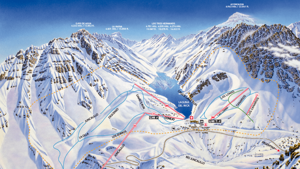
Menú The Portillo trail map spans a skiable terrain of 500 hectares (1,235 acres) with a total of 35 trails served by 14 lifts. The terrain is perfectly distributed for all skill levels: 15% for beginners, 30% for intermediate skiers, 30% for advanced, and 25% exclusively for experts. The mountain is world-renowned for its challenging off-piste areas and its iconic va-et-vient lifts (Roca Jack and El Caracara), uniquely designed to navigate extreme slopes prone to avalanches.
How to Read the Portillo Map: Sectors and Layout
Unlike other massive ski resorts with multiple interconnected valleys, Portillo features a natural amphitheater layout surrounding the Inca Lake. This makes orientation extremely simple: nearly all main runs converge back toward the base of the yellow hotel or the central lift access points.
When studying the map, you will notice that the terrain is essentially divided into the lower area (right in front of the hotel, ideal for taking your first turns) and the upper slopes, which require greater technical control as you gain elevation.
Terrain Breakdown by Skill Level
To ensure safe navigation across the mountain, runs are marked using international color and shape codes:
Green Zones: Absolute Beginners
Located just steps from the hotel terrace. Runs like El Corralito and El Puma offer wide, gentle, and protected slopes, perfect for the Ski School to conduct basic lessons without interference from fast-moving skiers.
Blue Zones: Progressing Intermediates
These form the heart of the intermediate domain. Runs like Las Lomas (one of the most popular, wide, and scenic trails at the resort) or the variations served by lifts like Conejo and Princesa feature moderate pitches ideal for perfecting parallel turns, gaining controlled speed, and smoothly enjoying the Andean scenery.
Black and Yellow Zones: Advanced and Experts
This is where Portillo becomes a global legend. Steep groomed trails like Garganta or Juncalillo demand excellent physical conditioning. However, the real draw for expert skiers is the off-piste terrain accessible from the highest lifts, where untouched powder awaits.
A Marvel of Engineering: The Va-et-Vient Lifts
When looking at the Portillo map, you will spot a unique icon for surface lifts called va-et-vient (slingshot/come-and-go). Invented in Portillo by engineer Jean Pomagalski in the 1960s, these lifts do not have intermediate towers installed on the slope surface.
Instead, they consist of a tow bar for 4 or 5 skiers that travels suspended by a cable anchored only at the bottom and top of the rock face. This prevents the structures from being destroyed by the frequent avalanches in the steepest chutes of the Andes. They are a rite of passage (and an adrenaline rush) for any advanced skier looking to conquer legendary lines like Roca Jack.
Mountain Technical Summary
| Technical Specification | Official Metrics |
|---|---|
| Base Elevation | 2,880 meters (9,448 feet) above sea level |
| Peak Elevation | 3,310 meters (10,860 feet) above sea level |
| Vertical Drop | 430 meters (1,412 feet) of continuous descent |
| Featured Trails | Las Lomas (Intermediate), Juncalillo & Roca Jack (Advanced/Expert) |
| Total Lifts | 14 (Double chairs, triple chairs, surface lifts, and va-et-vient) |
Frequently Asked Questions About Portillo’s Trails
Does the map feature exclusive areas for Snowboarding?
Snowboarders share all terrain with skiers. However, due to the nature of the *va-et-vient* lifts (which require holding an edge on a steep slope while being towed uphill), these lifts present high technical difficulty for riders on a single board. It is recommended to consult with the Ski Patrol before riding them for the first time.
How do I know which trails are open or closed each day?
Near the main Dining Room exit and at the base of the Ski School, you will find interactive digital screens displaying real-time trail status. Lifts or sectors marked in green are open, while red indicates temporary closure due to weather conditions, visibility, or avalanche control work by the patrol.
Want to study every corner of the mountain before you arrive?
Download the official high-resolution trail map to plan your descents, lunch spots, and technical progression routes for your upcoming ski vacation.